
Accuracy
Flood Insights accuracy mainly depends on
-
how much usable flood observation data we can obtain and
-
the quality of the terrain (DEM)
Flood depth accuracy also varies with the DEM: we use high-quality local DEMs where available, otherwise global elevation datasets (which can be inconsistent by region).
Flood depth targets ~30 cm MAE and is continually improving. Observations are harder in mountainous terrain, dense cities, and heavy canopy (forests/high crops) for SAR and sometimes optical.
Flood Insights merges multiple datasets with different accuracies by converting everything into a common coordinate reference system. Outputs are standardized to WGS84 (degrees), meaning raster pixels won’t be square in meters/feet and become slightly more north–south elongated away from the equator.
All inputs (including SAR layers and any customer overlays like policy locations, roads, or facilities) carry inherent uncertainty from their source/reference systems, which contributes to overall output uncertainty. For decision-making, align with ICEYE Customer Success and Solutions Engineering.
Estimated output accuracy tiers
Events analysed are broken down into a subset of flooded areas, each with an Estimated output accuracy tier. This represents the expected accuracy of depth and extent of the Flood Insights output based on the data used in the analysis. Estimated output accuracy tier is provided in two key documents: the extent file and the release notes.
TABLE 2: Accuracy tier description
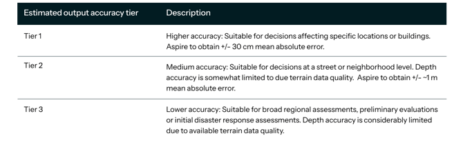
The achievable accuracy tier for tall and densely built areas and mountainous regions depends on the availability and distribution of diverse data sources, as well as the density of monitoring networks. The quality and quantity of incoming information significantly influence the attainable accuracy in these complex environments.