ICEYE's Wildfire Insights product is provided to users in a series of "Releases". Each release is provided on the basis of data availability. The aim is to deliver the first release within 24 hours of the trigger, with each subsequent release typically provided within 24 hours of the previous. The user should consider the most recent release as the authoritative view for a given event.
Each release contains the same set of files, following consistent naming conventions indicating the event ID and release number.
Building Damage Assessment (.gpkg)
A vector file providing centroids for every individual building footprint analyzed, each assigned a binary damage classification indicating whether a building is likely destroyed or likely not destroyed, based on SAR-detected signals within each building's footprint. Delivered in GeoPackage format, clipped to the current fire perimeter, georeferenced in EPSG:4326.
Schema (all columns always present, even when NULL):
| Column | Type | Description | Geography |
|---|---|---|---|
| damage | Integer (0 or 1) | 0 = likely not destroyed; 1 = likely destroyed | All |
| change | String or NULL | Indicates how a building's damage status has changed since the previous release. NULL in Release 1. | All |
| vendor_building_footprint_id | String or NULL | Vendor unique footprint identifier (Precisely BLDGID) | USA, CAN |
| vendor_address_id | String or NULL | List of vendor address identifiers (Precisely PBKEY), separated by ; | USA, CAN |
| vendor_address_detail_id | String or NULL | List of persistent address detail records (Precisely ADDR_ID), separated by ; | USA, CAN |
| building_pid | String | Geoscape persistent identifier for the building | Australia |
| address_pid | String | Geoscape address persistent identifier (G-NAF ID) | Australia |
| address_detail_pid | String | Geoscape unique persistent identifier for the address detail record | Australia |
| geometry | Point | Centroid of the building footprint | All |
Traceability (change field, from Release 2 onward):
| Value | Meaning |
|---|---|
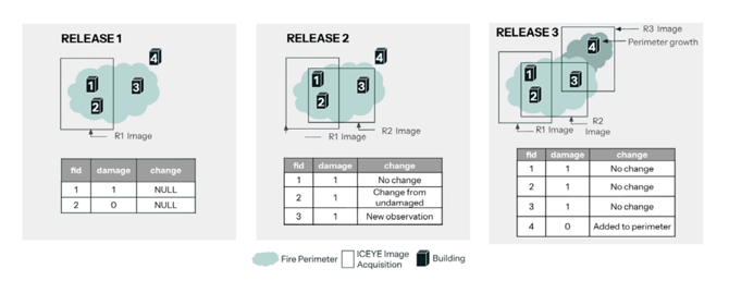
| No change | Damage status unchanged since the previous release |
| Changed from undamaged | Previously not destroyed, now classified as destroyed |
| Changed from destroyed | Previously destroyed, now classified as not destroyed |
| New observation | New ICEYE acquisition allowed assessment of a building within the perimeter not previously observed |
| Added to perimeter | The fire perimeter expanded and this building is newly included |
This feature is available for all events activated from 13 January 2026 onwards; historical releases prior to this date will not contain the change field.
Area of Interest / Fire Perimeter (.gpkg)
A polygon file representing the fire perimeter used to define the area analysed in each release. Perimeters are sourced from official third-party providers (e.g. WFIGS for the US, state fire services for Australia) where available; where unavailable, ICEYE derives perimeters from hotspot data.
Metadata
A machine-readable file for organisation and ingestion of releases, available via the ISS Delivery API response body. Includes event characteristics (event ID, name, country, start date), release number, total buildings analysed, total buildings likely destroyed, and analysed area.
Naming convention
| File | Template | Example |
|---|---|---|
| Building Damage Assessment | ICEYE_FIRE-{uid}_building_damage_R{#}.gpkg | ICEYE_FIRE-446_building_damage_R1.gpkg |
| Area of Interest | ICEYE_FIRE-{uid}_area_of_interest_R{#}.gpkg | ICEYE_FIRE-446_area_of_interest_R1.gpkg |
Note: ICEYE advises against hardcoding naming conventions in delivery integrations, to ease handling of future updates.
Example images
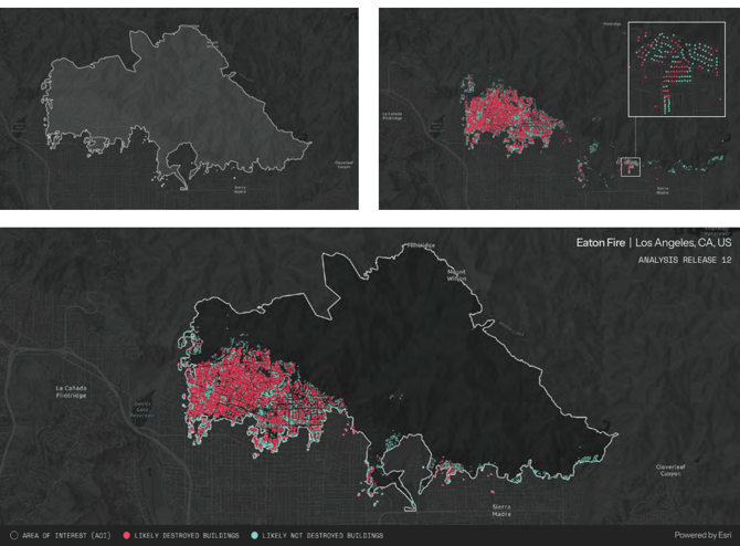
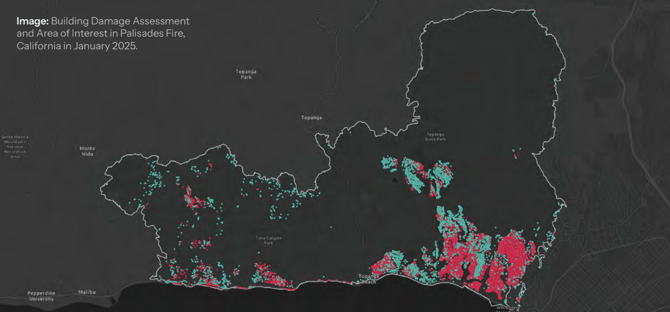
The images below show examples of the Area of Interest (left) and the Building Damage Assessment outputs. (right). Red dots indicate buildings classified as likely destroyed; green dots indicate buildings classified as likely not destroyed.